
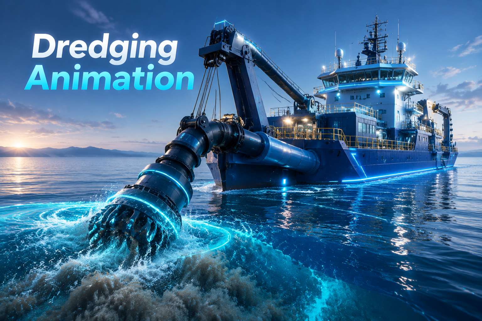
offshore infrastructure development, port expansion, and offshore energy projects are among the most capital-intensive, complex, and environmentally sensitive engineering endeavors in today’s industrial world. Due to operations in deep, turbid waters with near-zero visibility at the seabed, dredging contractors face significant challenges when communicating complex subsea workflows, sediment transport mechanics, and vessel kinematics to clients, port authorities, investors, and regulatory bodies. Sole reliance on 2D engineering drawings, static bathymetric charts, or dense technical documentation often leads to costly misunderstandings, protracted permitting processes, and lost opportunities in multi-million-dollar tenders.
This is where 3D engineering dredging animation becomes an essential asset for offshore civil and offshore engineering firms. A high-precision engineering animation bridges the gap between complex mechanical schematics and clear, persuasive visual storytelling. By transforming raw hydrographic survey data, Multibeam Echosounder (MBES) point clouds, and vessel CAD files into ultra-realistic Digital Twins, specialized offshore animation allows stakeholders to look beneath the water line and evaluate all critical phases of a drilling or dredging program with absolute clarity.
In this comprehensive guide, we explore the strategic role of dredging animation in winning tenders, analyzing vessel mechanics, soil cutting physics, modeling environmental requirements, and elevating offshore operations through engineering animation.
The Strategic Role of Dredging Animation in Commercial Tenders and Infrastructure Projects
Securing multi-million-dollar contracts for offshore infrastructure, land reclamation, or navigation channel deepening requires proving technical capability, operational precision, and strict adherence to safety protocols before a single vessel is mobilized to the project site. Tender evaluation committees, port managers, and government bodies often review massive volumes of technical documentation under very tight deadlines. When competing against international contractors, providing static “Method Statements” alongside standard CAD drawings creates an atmosphere of ambiguity and caution in decision-making.
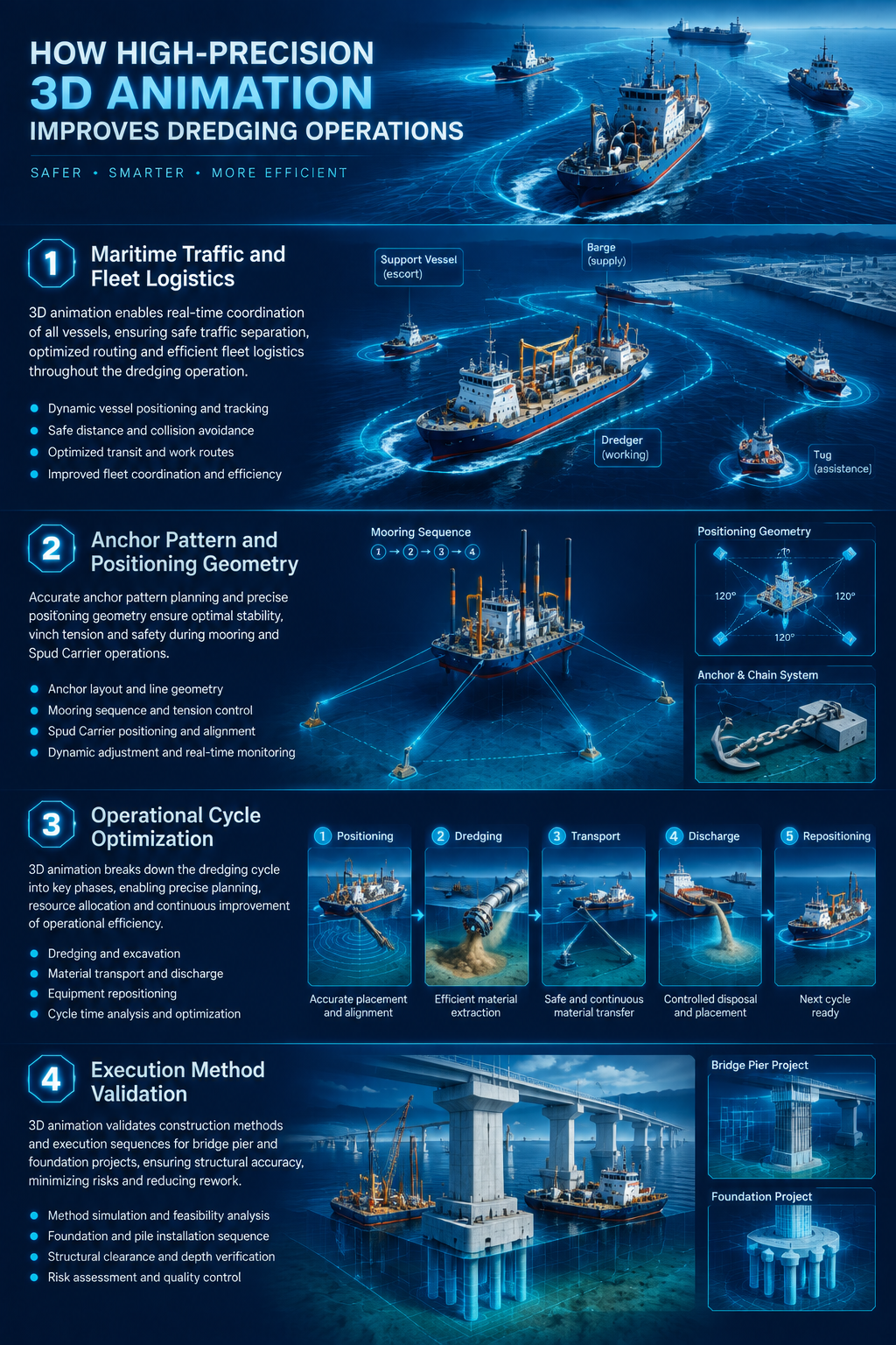
High-precision 3D animations transform abstract proposals into tangible, risk-free operational roadmaps. By visualizing the entire dredging operation step-by-step and with precise scheduling, contractors demonstrate total command over project logistics:
- Maritime Traffic and Fleet Logistics: Showcasing coordinated movements between main dredgers, split hopper barges, tugboats, hydrographic survey boats, and service vessels in busy commercial waterways.
- Anchor Pattern and Positioning Geometry: Visualizing multi-point mooring patterns, anchor handling, and the stepping sequence of the Spud Carrier to prove non-interference with maritime traffic or subsea assets.
- Operational Cycle Optimization: A step-by-step breakdown of the work cycle; from transit and suction dredging to hopper filling, overflow control, transit to the discharge site, and unloading via bottom doors or rainbowing to shore.
- Execution Method Validation: Providing visual proof for complex projects such as dredging under bridge piers (caissons), trenching for immersed tunnels, and preparing the seabed for offshore wind turbine foundations.
Technical Analysis: Comparing CSD and TSHD Simulations
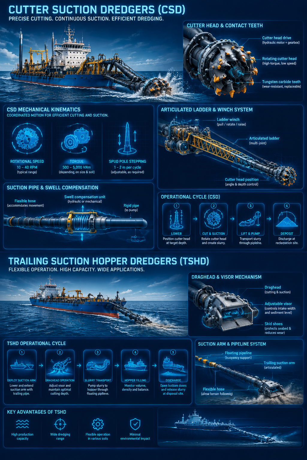
Dredging vessels are highly specialized engineering systems designed according to geotechnical soil conditions, water depth, and sediment discharge methods. Off-the-shelf, generic models cannot accurately represent the physical mechanics, moving joints, and operational capacities of various classes of dredgers. Engineering-grade animation reconstructs the mechanical components and kinematic structure of these vessels:
Cutter Suction Dredgers (CSD)
The CSD animation focuses on heavy-duty mechanical kinematics used for breaking hard rock, dense clay, and coral structures:
- Rotational Speed and Cutter Head Torque: Displaying the exact contact angles of individual teeth against hard rocky seabeds.
- Articulated Ladder Structure: Supported by heavy-duty winches and subsea trunnions.
- Spud Pole Carrier Stepping Cycle: Visualizing how the vessel anchors on a pile, swings in an arc using side winches, and advances systematically along the dredging line.
Trailing Suction Hopper Dredgers (TSHD)
For projects involving loose sand, gravel, and seabed silt, the animation focuses on the continuous cycle of this self-propelled vessel:
- Suction Arm Operation: Single or twin suction pipes deployed via davits.
- Active Swell Compensation: Maintaining constant contact of the draghead with the uneven seabed in turbulent conditions.
- Draghead Visor Mechanism and High-Pressure Water Jets: Used for loosening dense seafloor sediments.
- Slurry Suction: Monitoring internal hopper levels, overflow monitoring, and final discharge via bottom doors, split-hull opening, or rainbowing from the bow.
Seabed Bathymetry, Soil Mechanics, and Slurry Transport Dynamics
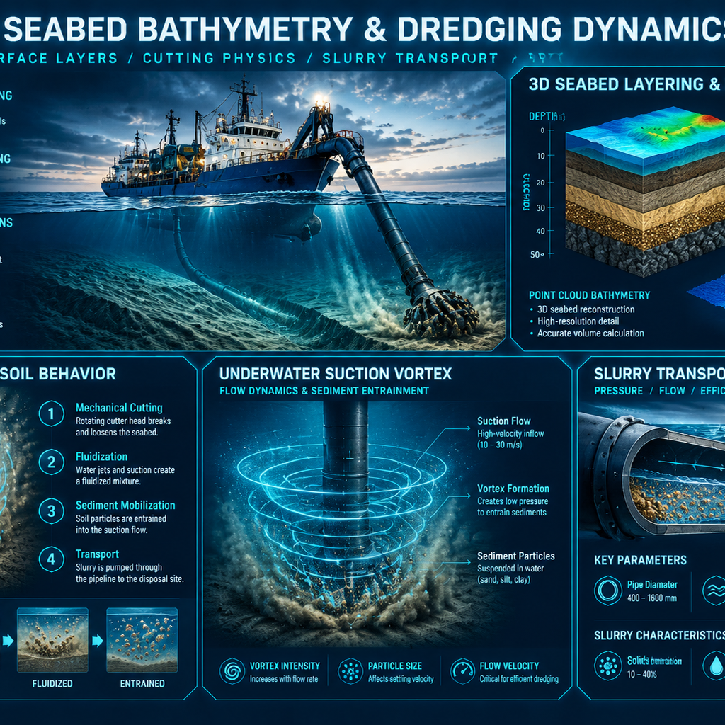
The primary operational challenge in dredging occurs in deep water, where zero visibility prevents real-world filming. Engineering animation utilizes hydrographic data to produce accurate Digital Twins of the ocean floor and sub-surface geology.
By processing point clouds from Multibeam Echosounders (MBES), side-scan sonar, and geotechnical borehole reports, the following are precisely modeled:
- Geotechnical Layering: Cross-sectional cuts of soil layers, from soft surface sludge and offshore sand to stiff clay lenses and rock beds.
- Cutting and Suction Physics: Penetration of cutter teeth, shear failure planes in the soil structure, and suction vortices around the inlet nozzle.
- Slurry Fluid Dynamics: Particle simulation to display density gradients, flow velocity (m/s), passage through the impeller and pump chamber, and high-pressure transport via floating or submerged pipelines.
- Post-Dredging Topography: Direct visual comparison of pre- and post-dredging bathymetry surfaces to demonstrate trench slope stability and permitted over-dredging tolerances.
Why Custom Engineering Animation Outperforms Stock 3D Models
Many companies initially attempt to save costs by purchasing inexpensive models from online stock libraries. While these models might be suitable for video games, they are entirely ineffective for industrial dredging applications.
|
Feature / Criterion |
Stock 3D Models |
Custom Engineering Animation (Fidar) |
|
Dimensional Accuracy |
Visual approximations with incorrect dimensions |
1:1 precise scale, engineered directly from CAD files |
|
Mechanical Kinematics |
Rigid structure, no articulated joints or winches | Precise rigging of cranes, ladders, and spuds based on mechanics |
|
Geotechnical Realism |
Simple flat planes as seabed | Mesh modeling based on real point clouds and survey data |
|
Fluid & Slurry Dynamics |
Static, primitive water surfaces | Particle simulation of hydrodynamic flows, turbidity, and slurry |
|
Engineering Credibility |
High risk of tender rejection | Referenceable Digital Twin based on offshore architectural standards |
Stock models lack critical components such as real trunnion joints, the travel stroke of swell-compensating cylinders, engineered draghead tooth configurations, and precise discharge manifolds. Conversely, specialized offshore animation is built upon industrial files (SolidWorks, STEP, Rhino, CATIA), ensuring every jack, pin, valve, and hull plate is millimeter-accurate to reality.
Compliance with Environmental Requirements, Turbidity Modeling, and Sediment Control
Obtaining an Environmental Impact Assessment (EIA) approval requires demonstrating that dredging will not harm sensitive offshore habitats, coral reefs, or fishing zones.
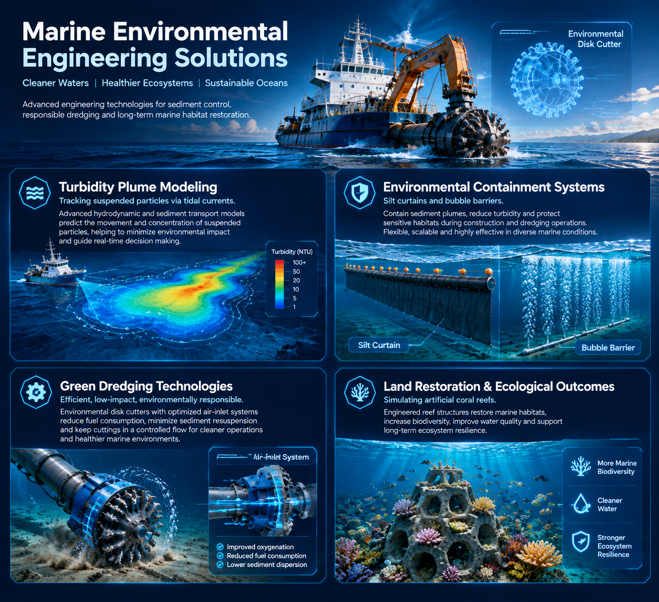
Specialized animations visualize mitigation strategies in a scientific and visual format:
- Turbidity Plume Modeling: Simulating the creation, movement, and deposition of suspended particles under the influence of tidal currents, salinity, and bottom slope.
- Environmental Containment Systems: Visualizing the deployment of silt curtains, bubble barriers, and anti-sediment nets around the dredging zone.
- Green Dredging Technologies: Demonstrating the operation of overflow valves equipped with air-inlet systems (Green Valve), environmental disk cutter heads, and low-turbidity dragheads.
- Land Reclamation and Ecological Restoration: Simulating long-term land restoration, construction of artificial coral reefs, and beach nourishment in multi-phase timeframes.
Crew Safety Training, Risk Management, and Offshore Hazards
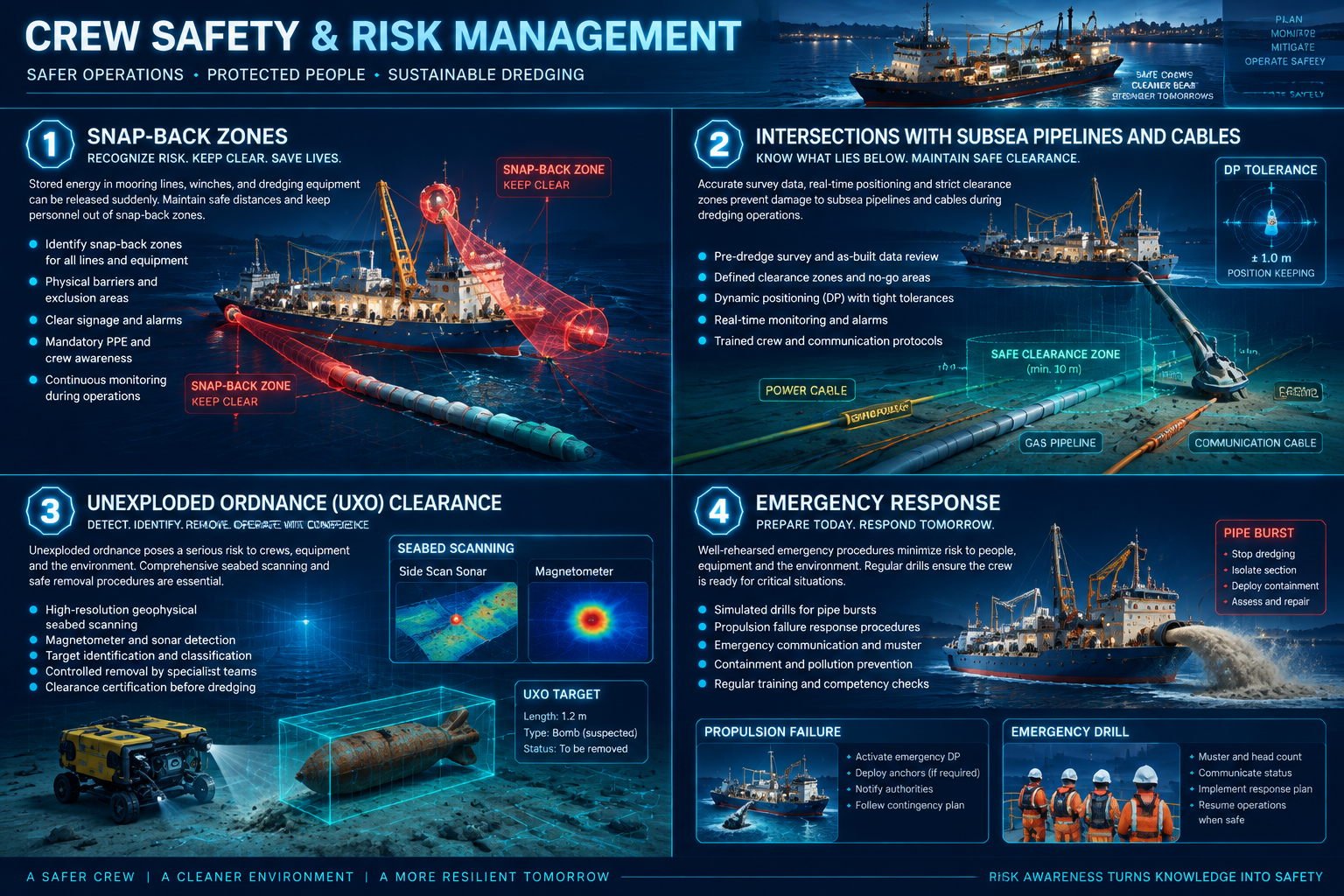
Dredging environments involve high-tension mooring cables, high-pressure slurry pipes, and heavy machinery. 3D animation provides a safe environment for crew training and HSE meetings:
- Snap-Back Zones: Visualizing high-risk areas and safe personnel transit routes on deck during anchor handling.
- Intersections with Subsea Pipelines and Cables: Illustrating clearance zones, Dynamic Positioning (DP) tolerances, and prohibited drilling zones near oil/gas pipelines or fiber optic cables.
- Unexploded Ordnance (UXO) Clearance: Detailing stages of acoustic seabed scanning, cautious excavation, and removal of wartime remnants using specialized grabs.
- Emergency Response: Simulated drills for immediate actions in the event of discharge pipe bursts, propulsion failure in strong currents, or emergency spud release.
Technical Production Pipeline: From Engineering Data to Final Render
Producing industrial dredging animation requires a data-driven pipeline that aligns with technical and engineering documentation at every stage:
|
Production Phase |
Engineering Input | Technical Output & Delivery |
|
CAD Ingestion & Optimization |
CAD Data (STEP, IGES, SolidWorks) & Bathymetry | Optimized 3D geometry maintaining strict tolerances |
|
Kinematic Rigging |
Mechanical constraints, pivot axes, hydraulic strokes | Fully articulated vessel with moving mechanisms |
| offshore Environment Setup | Wave spectrum data (Beaufort scale), water optical properties |
Realistic sea physics and underwater light attenuation |
|
Particle & Hydrodynamic Simulation |
SPH solvers, sediment particle size, pump discharge |
Soil cutting physics, slurry flow, and turbidity plume |
|
Technical Compositing |
Method statements, depth gauges, GPS telemetry data | 4K final video synchronized with telemetry data |
- CAD & Hydrographic Data Ingestion: Importing industrial formats alongside sonar point clouds and project methodology.
- Topology Optimization: Converting heavy CAD files into render-optimized meshes while preserving millimeter-level tolerances.
- Rigging and Motion Constraints: Defining mathematical constraints on winches, hydraulic jacks, cutter head axes, draghead arms, and spud carriages.
- Hydrodynamic & Sediment Simulation: Applying ocean waves based on the Beaufort scale alongside SPH particle simulation for accurate soil cutting and slurry suction.
- PBR Texturing & offshore Lighting: Simulating anti-corrosion coatings, anti-fouling hull textures, deck weathering, rusted chains, and the physics of light refraction in water (Beer-Lambert law).
- Post-Production & Telemetry Layers: Adding animated charts, dredging depth gauges, cutter speed vector displays, and professional narration.
Conclusion
With the expanding scale and environmental sensitivity of offshore projects, traditional methods are no longer capable of showcasing the engineering nuances of modern dredging. Dredging 3D animation, by integrating precise CAD files, real bathymetric data, sediment particle simulation, and hydrodynamic physics, offers a decisive tool for contractors, shipbuilders, and port authorities in tenders, safety management, and project execution.
Fidar Animation, as a specialized studio for offshore and subsea engineering animation, leverages deep knowledge of offshore architecture and advanced graphic processing to visualize your operational concepts with the highest technical accuracy and cinematic quality.
Our specialized offshore services include:
- Custom Animation of Dredging Vessels: Precise modeling of CSD, TSHD, Backhoe, and Grab Dredgers.
- 3D Bathymetry & Seabed Geology Modeling: Bed reconstruction from raw multibeam sonar data and borehole logs.
- Slurry Simulation, Cutting Physics, and Turbidity: Analysis of sediment particles, suction dynamics, and modeling of sediment curtain containment.
- Specialized Tender & Methodology Documentation Videos: Visual content creation for winning international port tenders.
- Pipeline/Cable Trenching and Land Reclamation Projects: Step-by-step animations of subsea infrastructure and beach nourishment.
- Interactive Digital Twins and Training Modules: Real-time simulations for risk assessment and crew HSE training.
For expert consultation on transforming your offshore project drawings and data into realistic and impactful animations, please contact the specialists at Fidar Animation.